
News
News | 6 min read
June 15, 2026
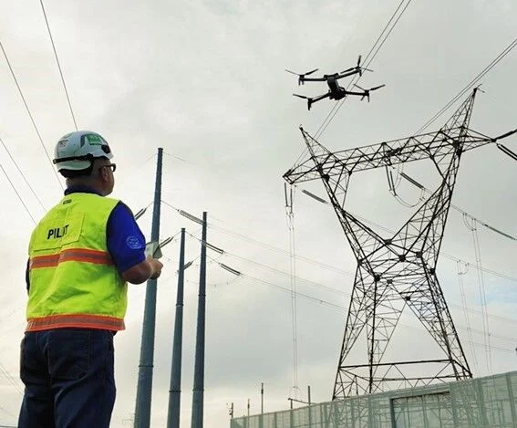
Dominion Energy’s grid operators picked up an unexpected power drop at the company’s Colonial Trail West solar farm during the sunny days early last week, so the request to check on it went out to the company’s new D-ROC — drone remote operations center — to be added to pilot Aaron Colgrove’s to-do list.
Dominion had recently stationed one of its 23 “drones in the box” at the Spring Grove substation next to the 142-megawatt solar farm in Surry County, and Colgrove had already carefully mapped the field and its 130 lines of solar panels, each 300 to 500 feet long.
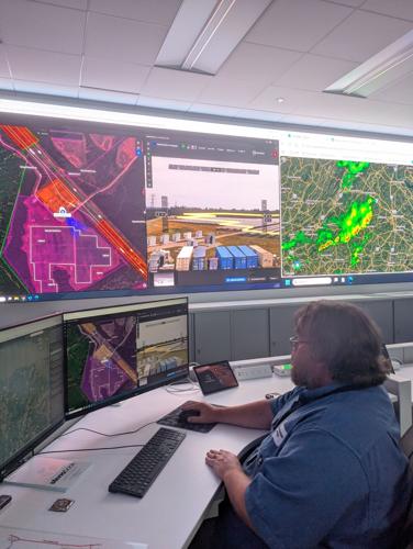
So it was a fairly straightforward matter for Colgrove to rev up the drone, tell it to head for one of its usual starting points in the northwest corner of the solar farm, and start running a lawnmower-like sweep up and down the lines of solar panels, located 50 miles away in Surry County. He really didn’t have to steer.
Colgrove kept the drone’s color video camera on as it approached the solar farm — his usual practice, using human eyes to backstop the drone’s own warning system if other aircraft were nearby. He switched the drone’s camera over to a thermal imaging sensor once he saw on another large screen that the blue spot showing the drone was on the edge of the pink blob showing the farm itself.
He was looking for overheating solar panels, which he knew were a likely explanation for a power drop. The screen that had been showing a bright, sunny day in Surry County — and no aircraft nearby — was now displaying a black-and-white overhead view of lines of pale gray solar panels — at just the right temperature.
But it took only about 10 minutes to find the issue. Although the drone picked up a few tiny white spots on panels showing a diode or two overheating, Colgrove found a line of about a dozen bright white rectangles at the northern end of the third line of solar panels. That showed the panels were too hot, indicating they weren’t generating the electricity they should.
Colgrove’s was one of thousands of missions Dominion’s Unmanned Systems Group’s pilots fly for the company. They inspect power lines, substations and areas of power plants that are hard for humans to reach. They do security checks, environmental surveys and mapping.
“It’s kind of a mix of what you’re taught and what you learn on the job,” he said.
The group is relatively new, comprising 10 Federal Aviation Administration-certified pilots who have logged more than 5,000 flight hours piloting drones over 10,000 miles of various Dominion lines and facilities. They each can handle any of the group’s 50 flying, walking, crawling and swimming drones.
Some, like the drone in the box — a relatively small spiderly-looking fellow that lives in a gray cabinet on legs where it can charge its battery, get weather and nearby aircraft checks, and receive directions from a pilot like Colgrove — are linked by internal cellular telecommunications gear so that the FAA allows Dominion to fly them when they are out of a pilot’s line of sight.
The group’s big white VTOL (vertical take-off-and-landing), which looks like a 6-foot-long airplane, can also be flown outside a line of sight — though Dominion pilots won’t, except in lightly populated areas, like the forests of western Virginia, where its power lines cross.
But being able to fly out of the line of sight means a Dominion pilot can guide the big VTOL at 45 miles an hour over many miles of a high voltage line, covering large areas in a fraction of the time a walking lineman could.
The VTOL also can fly closer to a line than a human pilot could dare to — or should — because it flies in the midst of a point cloud, a globe of data points generated by sweeping lasers that pick up any sign of obstacles as well as the position of the power line.
“It’s the difference between what you can see at 200 feet versus 700 feet with a bad cellphone image,” said T.F. Butler, manager of the Unmanned Systems Group, recalling the old days when it was up to linemen walking beneath a transmission line and eyeballing it for problems like an overloaded, overheated line drooping too close to the group or a insulator too loosely connected to wire and tower.
The LIDAR (Light Detection and Ranging) packages, which are among the cameras and thermal sensors that Dominion can load on its drones, can provide precise wire-to-ground distances and, for instance, see through vegetation to detect whether erosion is causing the land beneath a pole or transmission tower to slip.
The group has submersible drones it can use to inspect the foundations of towers that carry power lines across rivers and streams, as well as underwater lines, like those connecting Dominion’s under-construction wind farm, 25 miles out in the Atlantic off the Virginia Beach Oceanfront.
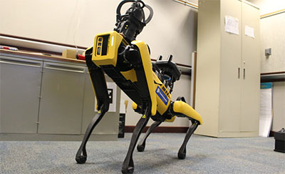
There’s also Odie the walking drone that, among other things, can dive into thickets where downed trees and live, fallen power lines after a storm pose real danger for any Dominion lineman trying to assess damage and figure out a fix.
“Safety is our No. 1 concern,” Butler said.
In addition to whether they fly, swim or walk, and whether they have arms and grasping mechanisms, Dominion pilots look at battery life, lifting capability, how fast a drone can move, the sensor packages or cameras it can carry and whether it can know how to dodge obstacles when deciding exactly which drone is right for which assignment.
So one of the smaller, black spidery drones in Dominion’s arsenal can let pilot Joel Cashman get close to the top of power line poles.
It will fly close to any object, pole or tree branch, for instance, and stop, look for a clear path, or wait for Cashman to take charge.
Near the top of a pole, for instance, Cashman can inch closer, take a view from straight overhead, then ease down a bit and get images from all four cardinal directions – north, south, east and west – before heading still lower to get an image from below.
“You can count the threads on a bolt to see if it’s pulling out,” Butler said. “You can’t see that from the ground.”
Original story from the Richmond Times Dispatch